| Home |
|
Welcome Very attractive and affordable tourist package –SERBIA , river Drina and its mountaines |
|
|
|
Partners: |
|
http://www.allhealthdirectory.com/page/travel-1.html |
|
References: |
|
-Ken Schoolland, professor of economic and political science at Hawai Pacific University, Honolulu, USA-e-mail-schoollak001@hawaii.rr.com -Virgis Daukas, university professor Vilnius, Litwania-e-mail-virgis3@yahoo.com -Geo Olson, tourist manager, Sweden, e-mail-geo@trollebo.com; GeoOlsson@hotmail.com--Dragoljub Petrovic Cale, in charge for tourisme, Community Ljubovija, 063-353670 -Rade Lazic, Mountain association PD”Kopaonik”, tel.011-3181065;Mob.tel-064-3464455 -Zoran Makitan, Mountaine assoc-PD Kikinda, tel-stan:0230-21414; posao:0230-23510 lokal 123;063-593984 -Dusan Bobic,Association-PD”Sremski Karlovci” tel.stan 021-849287;posao-021-4895074;Mob.tel-064-2036938 -Sveta Ljubinkovic, Associaton-PD” Pobeda “,tel. stan 011-2333334;063-247975 -Bosko Stanojevic, Association-PD” Pobeda “, tel. 011-3557861 - Dragan Petricic, Association-PD”Zeljeznicar”,tel.stan 011-3946745; posao-011-3972929; Mob.tel-064-2748632-Dait Ruben, Association-PD”Zanatlija” Novi Sad, tel.021-468189; Mob.tel-063-511395 -Dule Valterovic, Association-PD”Sabac”, tel.015-327535;063-308922 -Rada Pavlovic, Retired persons assoc- Novi Beograd, tel.063-7255154 -Zoran Vojinovic, “Drinska regata” Ljubovija, tel.015-663122; Mob. tel-064-2735034 -Dragan Pavlovic, Pop, Ljubovija, tel. etc |
 |
|
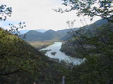
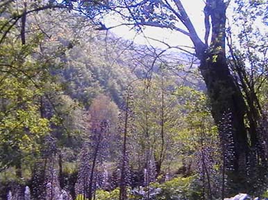
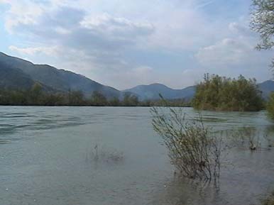
Tourist potentials of Drina and its tributaries are unique because of
its breath-taking scenery, and canyons of Tara, Piva, Komarnica,
Susica, Draga, Lim, etc. Tara canyon is equal to the canyon of the
Colorado river in the United States, except that it’s still not as
commercialized. In the confluence of Drina there are several very
beautiful lakes: Visegrad, Perucac, Zvornik lake, as well as some on
Piva, Lim, and Uvce. Very attractive and affordable tourist packages- “Health is the
greatest treasure, if you have health you have hope, if you have
hope you have everything.” Conatct: Tomislav Krsmanovic, Stanka Paunovica 70, 11090 Belgrade Home: 011-3511829, cell: 064-309-5176; pokret@eunet.yu The river Drina, its mountains, gorges, forests, meadows, tributaries, air, clean waters, its ecologically clean food, climate, honest and hospitable hosts, and authentic folklore, are the true recipe for human health! To say “Drina” is to say vacation, relaxation, health,
refuge from civilization, congested cities, and hurdles of modern-day life; “Drina” is an invitation for healing, strengthening the body, it is
the return of the optimism and life energy. This area is well known for these healing properties as well as the long preserved optimism of its residents. Drina, its mountains, woods, meadows, gorges, tributaries, air, clean waters, and ecologically clean food.
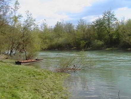
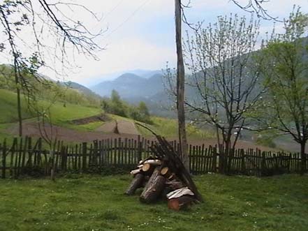
We offer: 1.RAFTING down the river Drina, this powerful, exceptionally beautiful mountain river: rubber boats with licensed guides, and 8 partition walls for up to 10 persons, or a tree trunk boat (smaller boats, as well as lifesaving vests, and insurance are available). Drina is not as dangerous for rafting as her upper tributaries, Tara and Lim, since it is a wider river with smaller falls, but it is still very exciting, rich and foamy, and enchanting with lovely sceneries of untouched nature. One day rafting excursions on Drina-10 euros only (two, or three day trips also available)! 2.LODGING IN MOUNTAIN VILLAGES, OR THE VALLEY NEAR DRINA (VILLAGE
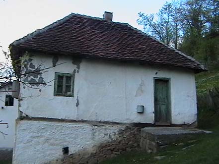
TOURISM) The price is 10 euros per day for a full package (lodging
and 3 meals included). The village of Uzovnica is at 160 meters of
altitude, in the proximity of mountains aboute 1500 meters of altitude, with Drina just some hundred meters away, and 5 kilometers away from Ljubovija by asphalt road. The village of Gornje Koslje is on 940 meters of altitude, 20 km away from Ljubovija, by Bobija mountain (1270 meters of altitude) and Povljen mountain (1400 meters of altitude). Prices are very affordable: FULL PACKAGE (lodging, breakfast, lunch, and dinner included), new, comfortable houses with baths, clean water from natural springs-only 10 euros per day! One day rafting excursions on Drina-10 euros only (two, or three day trips also available)! Come join us for an unforgettable time, and experience these beautiful rivers, eagles, caves, working mills from medieval times, meet our honest an friendly hosts, authentic folklore all in peace and tranquility of untouched nature. More about Drina and villages with available lodging These villages are located in the middle part of Drina’s flow, in Ljubovija county, Serbia. River Drina and its tributaries are
exceptionally beautiful mountain river flows, well known and admired
not just by locals but Europeans in general. This is the world known “Drina flow” that was for political reasons until recently forbidden. Now is the time to reactivate these incredible potentials!
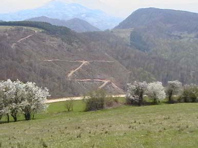
Drina is the right and the largest tributary of the river Sava, which is the natural boundary between Serbia and Republika Srpska (Bosnia). It is formed from two smaller rivers- Piva and Tara that merge together in Montenegro, near Scepan Polje at the altitude of 431 meters, and flow into the Sava river at Raca at the altitude of 75 meters. Vertical fall is 355 meters, with general fall 1% which makes Drina a very fast river. Drina is a very water rich river, 346 kilometers long, and 175 km in a straight line. The reason for this large difference is in its many curves (Drina is also called “The European Meander”). It is clear that a river such as this one with its rich water resources, and beautiful natural setting makes a first class tourist destination! For centuries, rafting was popular on Drina, with rafts being made on river Tara, or lower by the river Drinjaca by Zvornik, with some of the rafts going all the way to Belgrade. For centuries, Drina has inspired some of the most popular poets, writers, and artists, and local as well as foreign travelogue writers… Drina and its tributaries carve high mountains and penetrate deep into the canyons and mountain passes, at some places above 1500 meters deep. For the longest time Drina was considered a holy river by the Orthodox as well as the Muslims who live in Bosnia (Republika Srpska). Tourist potentials of Drina and its tributaries are unique because of its breath-taking scenery, and canyons of Tara, Piva, Komarnica, Susica, Draga, Lim, etc. Tara canyon is equal to the canyon of the Colorado river in the United States, except that it’s still not as commercialized. In the confluence of Drina there are several very beautiful lakes: Visegrad, Perucac, Zvornik lake, as well as some on Piva, Lim, and Uvce. In its middle part of the flow, near the villages Uzovnica and Gornje Koslje, Drina is in its upper part a mountainous, and in its lower parts a semi-mountanious river, wide, at times very narrowed, powerful, with beautiful, wild tributaries such as Gornja Tresnjica, as well as Ljubovija, Gracanica, Uzovnica, Jadar, and Drinjaca. In its upper parts you can find high mountain peaks of Montenegro, with 17 peaks above 2500 meters of altitude. In its middle part, near Ljubovija, in Serbia there are several mountains up to 1500 meters of alititude, and in nearby Bosnia the famous Olympic complex of mountains above 2000 meters, the place of the 1980 Sarajevo Winter Olympic Games. In the confluence of Drina there are several famous national parks: Durmitor, river Tara (Tara canyon, protected by UNESCO with cliffs as high as 1700 meters is equal to the Colorado canyon in the United States), Tara mountain, Tjeniste-Sutjeska (where you can find the only primeval forest in Europe-Perucica). Drina’s river flows, passes, surrounding mountains and peaks, forests, flora and fauna, air, and clean waters all make this river unique because it connects waters with mountains, living creatures with plants. This is a unique natural mix-potion for health and recuperating. There are 300 different kinds of fish in Drina, its tributaries and its lakes. There are many springs and sources of mineral-rich waters, as well as large and small beasts (bears, wolves, foxes, rabbits, alpine goats, wild pigs, does) and birds (eagle, partridge, sparrow-hawk, pheasant etc). Numerous culturally and historically significant spots are old town-fortresses (some preserved, others in ruins), churches and monasteries, monuments, cemeteries, diggings… This area is very suitable for all aspects of tourism, such as rafting (150 km long), kayaking, (70
km on high speed waters), cruising with kayaks, gliders, motor boats on lakes, fishing, hunting, mountain hiking, excursions, visiting secluded villages, parasailing, camping, swimming, visiting cultural and historical monuments, being with nature that gives health. Even with such variety of tourist attractions, this area is not over-flown by tourists, or commercial hotels. Climate is moderate continental while at altitudes of over 700 meters it becomes sub- alpine, with many sunny days… Ljubovija county is the center of Srednje Podrinje. The center place of the county is the town called Ljubovija (at 190 meters of altitude). It is 600 meters away from Drina, with some 6000 residents which is one third of all residents of Ljubovija county. Considering the large area that this city encompasses, there are a very small number of residents per square meter. Drina is positioned on the altitude of 190 meters on the entrance to Ljubovija county (between Ljubovija and Bajina Basta-Okletac) and 160 meters on its exit near Velika Reka. Its width ranges from 50-200 meters; at some places it is as narrow as 20 meters. It forms numerous islands (Adas). It flows through Ljubovija County by some 38 km in length, while her absolute fall is about 25 meters. Maximal dept of water is about 700 m (15.12.1952), and minimal 13 cm (13 and 14.12.1927), with the average of 136 meters. High waters are frequent in springtime, as well as November and December, while low waters are common in the summer and at the beginning of fall…Its average annual count is 359m3/s.
Different tourist groups can visit this region for various reasons and motives: -Picnics and excursions for alpinists, retired folks, and disabled -Visiting for vacations -Health tourism -Foreign visitors -Rafting down Drina -Swimming -Fishing -Rowing, kayaking, canuing, gliding -Visiting monasteries (Soko and others), churches… -Drina’s regatta -Ecological expeditions -Ethnological excursions -School tourism -Transit and automobile visitors -Camping -Paragliding -Speleologist associations -Alpinism -Sport teams -Congresses, meetings -Business trips, etc
Ljubovija is connected with Belgrade by asphalt road. It is only 200 km away from the capital, with excellent bus routes that frequent it several times per day, and also connect it to many other cities and towns. The price of the bus fare is about 500 dinars one way(aboute 5 euros), and it takes you to Ljubovija in 4 hours. I am at your service for any questions or needed information. Good luck, Tomislav Krsmanovic
|
|
|
|
|
|
Tomislav Krsmanovic, Stanka Paunovica 70,11090-Beograd Tel-011-3511829; Mob tel-064-3095176; Pokret@eunet.yu |
| Zoran Dimitrijevic Production nacomp@EUnet.yu 063-210-.302 |